Interactive Map Reveals Duke In Many Dimensions
Online map offers 3-D views, helpful information for visitors and Duke community

A visitor to Duke can now walk through gothic arches, take a peek inside Cameron Indoor Stadium and inspect stonework on Duke Chapel's 210-foot tower without even stepping foot on the 9,350-acre campus.
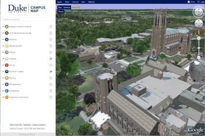
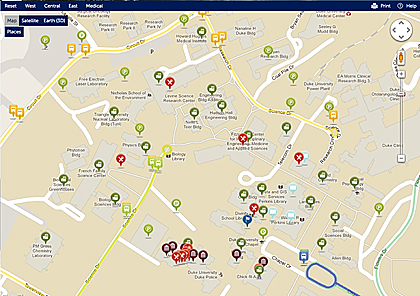
Duke unveiled a new online map Friday that includes 3-D models of 325 buildings across the campuses. The map also includes satellite views and traditional two-dimensional street maps and offers overlays that display details such as dining locations and parking permit requirements, photos related to the buildings and videos linked to specific campus locations. The map is fully functional on mobile devices.
Read More"The 3-D model is a great way to introduce the campus to visitors and prospective students," said Christoph Guttentag, dean of Undergraduate Admissions at Duke. "But the map will also allow us to create virtual tours that can mix a 3-D view of campus with videos of what happens inside the buildings, from dance to lectures. It's a great way to bring the campus to life."
The interactive map, built on the Google Maps engine, is the result of five months of intense data gathering from multiple departments at Duke. It has been called a "revolutionary tool," allowing users to explore Duke in many dimensions. Viewers can immerse themselves in the 3-D model through the Google Earth application, view a more traditional Google Maps two-dimensional map and add layers of information based upon their own interests.
"People have high expectations of Duke and this new map meets those expectations with sophisticated online mapping technology," said Blyth Morrell, senior web and vendor consultant in the Office of Marketing & Strategic Communications, and project leader for the map redesign.

Click on the "Dining" overlay and 22 red pushpins with an icon of a knife and fork reveal the locations of campus eateries. Click on a pushpin for Duke Chapel under "Points of Interest" and a 360-degree panoramic view of the Chapel becomes available for viewing. Scroll over to the Admissions Building, and another pushpin reveals a 30-second video for prospective students.
The map also allows users to add a "Transportation" overlay for Duke bus stops and bus routes, bike racks and parking lot information.
Beth Campbell, information systems manager for Parking and Transportation, said the new map will help Duke community members and visitors navigate Duke's transit options.
"When it comes to transportation, people may not want lists of general information on websites," she said. "They want detailed information based on the specific location where they are now or where they are going. This map will get us much closer to providing that."
The traditional two-dimensional map includes Duke's campuses outside of Durham such as the Marine Lab in Beaufort and the Duke-NUS Graduate Medical School in Singapore - complete with the additional layers of information. Eventually, Duke's campus in Kunshan, China, will be included.
"A campus map that didn't reflect these locations would present an incomplete picture of Duke," said Mike Schoenfeld, vice president for public affairs and government relations. "We will eventually have 3-D models of all these campuses, but it will take time to gather all of the images and information."
For the 3-D experience, users click on the "Earth (3D)" tab in the upper corner of the map. The Google Earth application opens and zooms in to Duke's campus from a view of Earth hanging in space. Viewers can roam the campus and view the exteriors of 325 buildings from any angle, including zooming up to the gargoyles.
"This is the most compelling part of the map," said Morrell. "The models are so detailed that as you move, even the views through the arches of the Chapel change."
Duke worked with concept3D, a computer modeling and mapping vendor, to create the online map. The 3-D models are based on thousands of photos of Duke taken this summer. Duke also provided aerial photography and architectural drawings to define the buildings. Additional information for the map came from administrative offices dealing with facilities, transportation, police, disability, student affairs and admissions. Meg McKee of Duke's Office of News and Communications helped write and edit hundreds of building and site descriptions for the map.
"This map is a revolutionary tool for Duke, and the project was a case study in collaboration," Schoenfeld said.
In addition to helping visitors to Duke, the new online map will assist Duke staff and faculty in their work. Facilities Management, for example, plans to use the map to help guide the size and location of new buildings or additions.
"With a 3-D model, it is much easier to see what sight lines might be interrupted, or how a building fits with the neighboring buildings," said Greg Anspach, GIS manager for Facilities. Beginning in 2012, the maps team will work with departments and units interested in developing the map for local purposes, such as adding photos or videos of the interiors of buildings, creating virtual tours of a specific school, integrating the map into events calendars or planning an evacuation route.
"We've got a great foundation here, which allows us to meet the growing expectations users have about online maps," Schoenfeld said. "The fun stuff now will come as the Duke community thinks about how to use it in new and different ways."