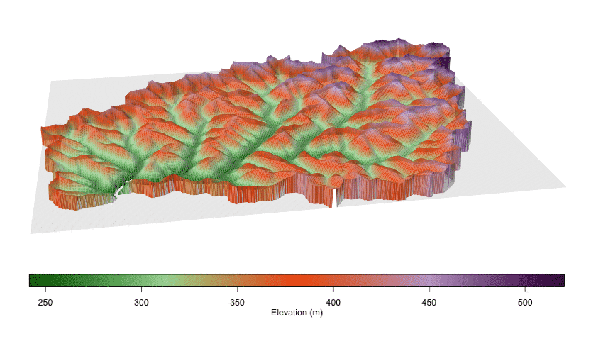
Years of blowing away mountain ridges in search of coal and depositing the excess rock in nearby valleys have dramatically flattened the landscape in parts of Central Appalachia. This animation shows an elevation map of West Virginia’s Mud River watershed before and after mountaintop mining became widespread.Photo credit: Photo courtesy of Matthew Ross, Duke University.
Forty years of mountaintop coal mining have made parts of Central Appalachia 40 percent flatter than they were before excavation, says new research by Duke University.
The study, which compares pre- and post-mining topographic data in southern West Virginia, is the first to examine the regional impact of mountaintop mines on landscape topography and how the changes might influence water quality.
“There hasn’t been a large-scale assessment of just the simple full topographic impact of mountaintop mining, which occupies more than 10 percent of the land in the region we studied,” said Matthew Ross, an ecology PhD student and lead author on the study.
“[We found] the impact is deep and extensive,” Ross said. “It is locally large and more wide-ranging than other forms of mining.” The study is published online in the journal Environmental Science and Technology.
In mountaintop mining, bedrock is blasted away to uncover coal seams below the surface. Excess rock is deposited in nearby valleys, creating what are called valley fills.

The hillside slope of West Virginia’s Headwaters Twentymile Creek watershed pre- and post-mining, calculated from elevation maps. Images from http://www.minedwatersheds.com/.Photo credit: Photo courtesy of Matthew Ross, Duke University.
By comparing digitized topographic maps from West Virginia before mountaintop mining became extensive with elevation data collected by aircraft in 2010, the researchers found that the mines and valley fills could range anywhere from 10 to 200 meters deep. Across the region, the average slope of the land dropped by more than 10 degrees post-mining.
As part of the study, Ross collaborated with Duke University’s Data+ program to develop a web-based app that allows users to toggle between pre- and post-mining topographic maps in each watershed of the study. The app dramatically visualizes how the landscapes have been flattened by the transfer of rock from mountain peaks to mountain valleys.
“We tend to measure the impact of human activity based on the area it affects on a map, but mountaintop mining is penetrating much more deeply into the earth than other land use in the region like forestry, agriculture or urbanization,” said Emily Bernhardt, a professor of biology at Duke and co-author on the study. “The depth of these impacts is changing the way the geology, water, and vegetation interact in fundamental ways that are likely to persist far longer than other forms of land use.”
Of particular interest to the team is how the conversion from solid bedrock to porous valley fills changes the way water moves through the area, and whether this increases the likelihood that water will pick up alkaline mine pollutants.
“You go from having shallow soil that is between half a meter and two meters deep, to something that is like a soil that is a hundred meters deep. The way the water moves through those two different landscapes is really different,” Ross said. “There are valley fills that are the size of an Olympic swimming pool and then there are valley fills that are 10,000 Olympic swimming pools, so there is a huge range in the capacity they have to hold water.”
Ross says the data from this study indicates a correlation between the total volume of displaced rock and the concentration of certain pollutants, like selenium, downstream.
“We have data that the water quality impacts can last at least 30 years, but the geomorphology impacts might last thousands of years,” said Ross. “Once you have these flat plateaus, it sets up a whole new erosion machine and a whole new way that the landscape will be shaped into the future.”
Bernhardt said the findings should also inform planning in the region. “Even if we stopped mountaintop mining tomorrow, what kind of landscape is going to be left behind, and what are the constraints on what the landscape can be used for?”
Other authors include Brian McGlynn of the Nicholas School of the Environment at Duke University. The web-based visualization tool was developed in collaboration with Aaron Berdanier, Tess Harper, and Molly Rosenstein.
This research was supported by grants from the Foundation of the Carolinas, the Wireless Intelligent Sensor Network IGERT (Grant #DGE-1068871), the NSF Graduate Research Fellowship Program, and the NSF Hydrologic Sciences Program (Grant #EAR 1417405). Data used in the study was provided by the West Virginia Department of Environmental Protection.
CORRECTION: Due to a calculation error, the original version of this release stated that mountaintop mining has made Central Appalachia 60 percent flatter. Central Appalachia is actually 60 percent as steep or 40 percent flatter.
CITATION: "Deep Impact: Effects of Mountaintop Mining on Surface Topography, Bedrock Structure, and Downstream Waters," Matthew R. V. Ross, Brian L. McGlynn, Emily S. Bernhardt. Environmental Science and Technology, January 22, 2016. DOI: 10.1021/acs.est.5b04532